|
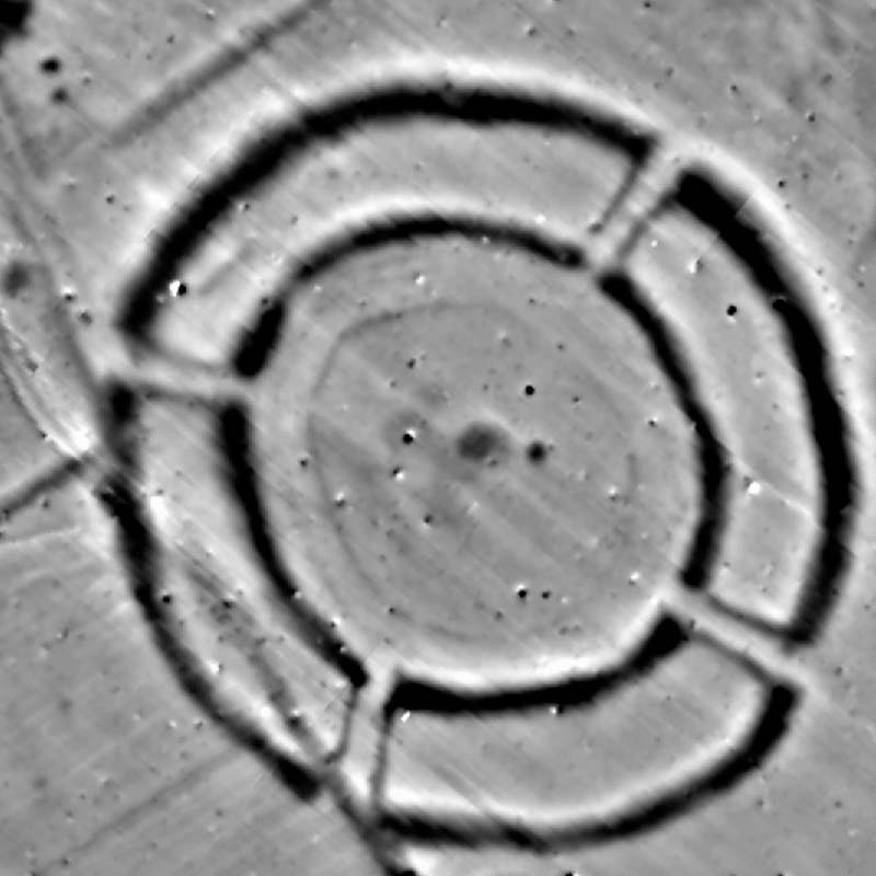
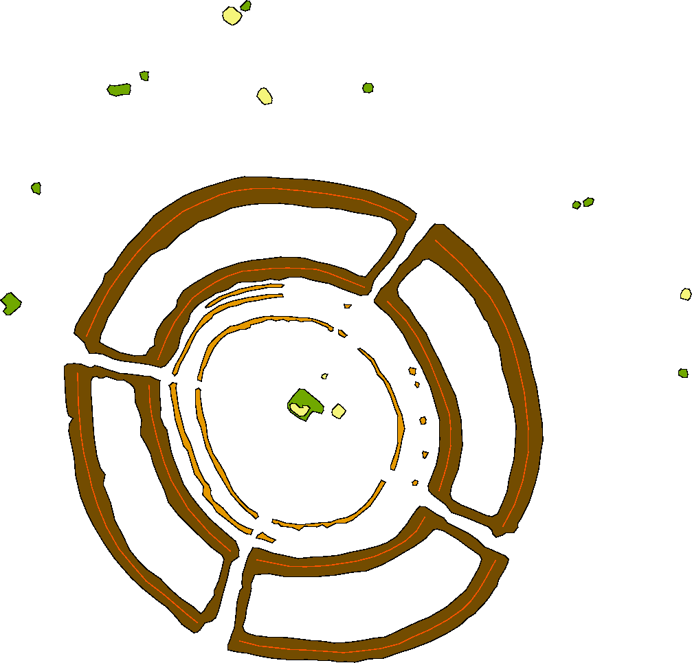
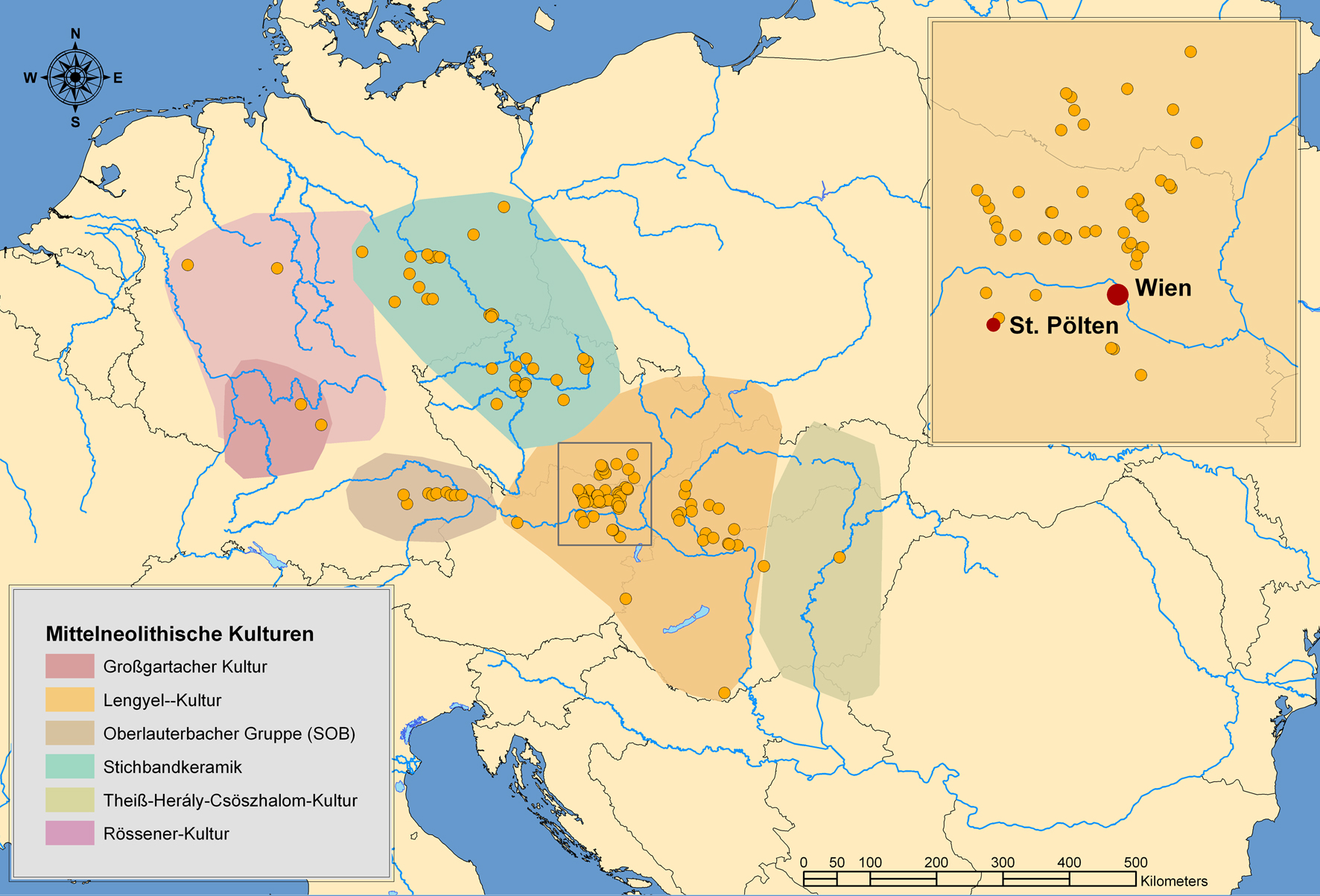
In the 1980s, a new group of large Neolithic monuments has been identified mainly due to systematic archaeological prospection, i.e. aerial archaeology and magnetic prospection [Nikitsch 1985; Trnka 1991; Becker 1990; Doneus et al. 2001; Neubauer 2001]. They typically consist of 1 to 4 nearly circular concentric ditches with 40 up to 300 m in diameter. The normally 6 to 10 m wide ditches show a specific pointed V-shape profile and were dug into the sandy or loess subsoil up to 6m depth. Narrow interruptions in the ditches formed the entrances into the interior which was enclosed by 1 to 5 rings of wooden palisades [Daimand Neubauer 2005]. Up to now about 140 of these earliest monumental buildings erected by early farming societies have been found over a large part of Middle Europe [Trnka 2005]. Their distribution ranges from Hungary [Raczky et al. 2005; Zalai-Gáal 1990], Slovakia [Kuzma 2005], Austria [Neubauer and Melichar 2005; Neubauer 2007], Czechy [Kovárník 2003; Hašek and Kovárník 1999; Podborský et al. 1999; Pavlů 1982], Bavaria [Becker 1996, 1990; Schmotz 2007] to Eastern Germany [Stäuble 2007; Bartels et al. 2003; Bertemes and Northe 2007; Bertemes et al. 2004]. These wooden monuments form a first pan-european phenomenon crossing the cultural borders defined by the archaeological material record [Neubauer and Trnka 2005; Trnka 2005] (Fig. 1).
|
First compilations of all known monuments were published by Petrasch [1990] and Trnka [1991], the latter proposed the term: mittelneolithische Kreisgrabenanlagen for this specific type of monument. The highest density of these fascinating monuments is found in the eastern part of Austria, mainly in the County of Lower Austria (e.g., Fig. 2 by Neubauer [2007]). Over 40 Kreisgrabenanlagen or KGAs are known so far for the main area of interest of this project. The monuments in eastern Austria normally are part of large settlements and enclose a specific area of typically 0.5 to 1.2 ha. According to 14C dating of bone material excavated from the ditches in Lower Austria, the KGAs have been erected in the very short time span between 4850/4750–4550/4500 BC [Stadler et al. 2006]. This short period seems to be valid for the other Middle European KGAs as well.
|
The function of these exceptional monumental buildings which have been erected by the early farmers with a high effort of work is still under scientific discussion. The interpretation models include socio-cultural or socio-ritual centers [Neubauer 2007, 222-236; Podborský et al. 1999], fortifications [ Nemejcová-Pavúková 1995], market places [Stäuble 2002, 307] or functions to safeguard people and their herds [Pertelwieser 2001] up to functional explanations as calendrical buildings, astronomical observatories or solar temples [Weber 1986; Becker 1996; Bertemes and Schlosser 2004; Zotti 2008; Schier 2008]. After the initial very contrary discussion phase there is a trend obvious towards multifunctional interpretation models [Neugebauer-Maresch 1995, 87; Stäuble 2007, 180; Neubauer 2007,217-236; Petrasch 2001]. As the monuments were not erected in strategic positions and because they have many regular oriented entrances the interpretation as fortification seems unlikely [Trnka 1991, 317]. As well we do not think that they represent emphasized settlement areas as there are no indications of buildings inside the monuments beside the palisades or single posts. The ditches and palisades form an enclosure, their perimeters separate the outside from the inside. The narrow entrances strictly control the access to the interior mainly invisible from the outside [Gibson 2005]. This element of limited access seems not to be based on fortification reasons but could be based on ritual activities [Stäuble 2007; Neubauer 2007; Gibson 2005] to be seen in a social context of the early farmer societies.
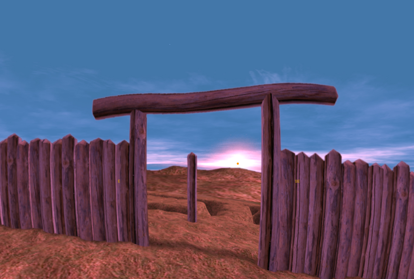
Contrary to the much younger megalithic monuments like Stonehenge [Hawkins 1973; Thom 1967; Thom and Thom 1978], the continental wooden KGAs are not preserved in the landscape. As soon as the first maps were available the KGAs became subject of archaeoastronomical considerations. The main interest was set on the orientation of the entrances [Weber 1986; Becker 1996; Karlovský 1999; Karlovský and Pavúk 2002]. Ritual sky observations have been proposed most notably by Becker [1996], who based his analysis on magnetograms that indicated that the entrances of the Bavarian KGAs are oriented towards rising or setting points of the Sun at the solstices.
In preparation of a large County exhibition on Kreisgrabenanlagen in 2005 [Daim and Neubauer 2005], the theory of astronomical aspects has also been investigated for the KGAs of Lower Austria [Zotti forthcoming, 2005, 2008; Kastowski et al. 2005]. This preliminary research was based on the results of a systematic archaeological prospection combining field surveys, aerial archaeology and magnetic prospection [Neubauer 2007]. Our approach was different from the theoretical considerations so far as we based our studies on archaeological interpretation maps and reconstructions based on magnetic modeling of the magnetic surveys [Eder-Hinterleitner and Neubauer 2001] combined with the digital terrain models derived from aerial archaeology [Neubauer 2001; Doneus et al. 2005]. Therefore it became possible to include the horizon and to derive virtual reality models of the monuments [Gervautz and Neubauer 2005]. These models formed the input for astronomical simulation software which made it possible to explore the astronomical aspects and the constraints in the reconstructed virtual Middle Neolithic scenery [Zotti 2008].
According to these first investigations on selected monuments from Lower Austria, solar alignments of entrances could be verified for several KGAs even with a higher degree of detail and reliability than the previous approaches. A first — preliminary — investigation into stellar alignments revealed promising indications on the possible observation of distinct bright stars as well. Our preliminary work promises remarkable future results towards the astronomical aspects of the KGAs by a thorough archaeoastronomical analysis based on comparable data of the monuments. This comparable and comprehensive data base exists so far only for the KGAs of Lower Austria and is based on a preliminary research project investigating all known KGAs. The resulting digital archive provides georeferenced aerial and magnetic prospection data, digital terrain models, archaeological interpretation maps and excavation results [Neubauer and Melichar 2005].