
All 33 project sites were visited, and the horizons surveyed with a total station. In addition, photographs were taken and combined into panoramas using Hugin, enriched with a diagram showing relevant astronomical information. An iterative adjustment ensured that the panoramas are aligned with the surveyed line. The treeline causes some apparent mismatch where in the processed photograph some fine twigs are invisible which had been measured.
The panoramas were also compared with artificial horizons created with Viewfinder Panorama software, which allowed corrections in the dense treelines - this explains the semitransparent vegetation. In general the match between artificial and measured horizons was found to be excellent as long as the horizon was further away than a few hundred meters. With a more dense digital elevation model, the requirement for on-site measurements may decrease in similar cases in the future.
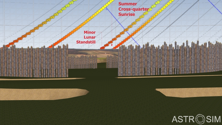
The diagram behind the photo combines the most notable solar and lunar events and bright stars of epoch -4800 in order to inspect directions which were under suspicion of being important in the KGA architecture, especially entrance directions. For the sun, these are winter and sommer solstices, equinoxes (where the sun follows the celestial equator) and the cross-quarter (or mid-quarter) days, which are right between solstices and equinoxes. The moon provides southern and northern standstills, which oscillate between major (northern and southern extremes) and minor standstills (the chains of moon icons close to the cross-quarter solar chains). The lunar chains appear to be shifted towards the south by the effect of lunar parallax. The slightly different sized lunar icons show the Moon's diameter in apogee and perigee.
The azimuths are relative to geographic north.
Except for the totally destroyed KGA Pottenbrunn, at least the far horizon for the sites may be assumed to have shown a very similar altitude in the Neolithic. The altitudes read off at the azimuths of the entrances can be converted to astronomical declinations which help to identify celestal objects which would have been seen rising or setting in those entrances.
Click on "Horizon Panoramas" in the Navigation bar or here to access the panoramas.
Update 2017-10-06: After the abolition of Java support in most Browsers the panoramas were reprocessed with the MarziPano Tool.
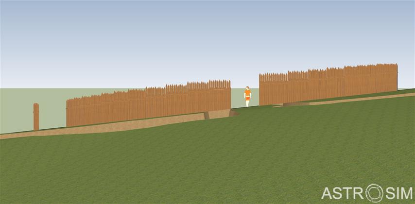
Based on the magnetograms derived from earlier surveys, virtual 3D models were constructed in a digital terrain model. These models may appear sketchy or strongly simplified and certainly much more can be done to provide an archaeologically sound virtual reconstruction, but these models were enough for geometrical considerations.
To create a visually more pleasing simulation environment, we chose the open-source desktop planetarium Stellarium. In addition to creating static horizons from Sketchup, we developed (in collaboration with students from the Institute of Computer Graphics and Algorithms of TU Vienna) a plugin that allowed the visualisation of a 3D model in the foreground, where the observer can walk around and explore the scenery, find observing locations, view through entrances etc. This program would have been an almost perfect presentation environment for the stellar orientations that were the main topic of this project, alas - this cannot be demonstrated here. Given its potential use for similar studies, the plugin has been made available in Stellarium 0.13.3, you can find it in the regular download. It includes a test scene and also a model of the Vienna Sterngarten which helped testing the accuracy of the simulation. (A simplified version of the model can also be seen in Google Earth when you activate the "legacy 3D buildings" layer).
Most archaeological publications show KGA maps with indications ditches, pits, finds, but without any indication of the terrain. The prominent KGAs invited an interpretation of the entrance orientation with respect to cardinal directions or astronomically defined directions like solstice or lunistice orientation, and our preliminary investigation (2005) had even promising indications on orientations towards a few stars. We again have to point out here that for the simple observations proposed in all these orientation studies, the immense effort to build a KGAs is not necessary, while it was seen to be probably connected to a ritual function during foundation or use of the KGAs, so the label "Observatory" found in some media must clearly be rejected. With this project, we wanted to clarify and either confirm or reject definitely, astronomical orientation of KGA entrances.
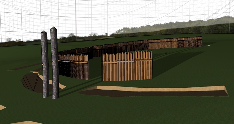
After initial confirmation of a few previous finds, it turned out however that the stellar orientation of other entrances previously indicated cannot be supported any longer - the measured horizon line too often does not provide the necessary altitude. But the horizon altitudes also contradict some other earlier results associating entrances with the sun or moon. On the other hand, with the virtual models reconstructed in a larger digital elevation model, it became evident that we can find a simple explanation for most of the entrances as leading "up" or "down" the sloping terrain, or in other cases the entrances are on the contour line (perpendicular to the slope line). This result removes any necessity for postulating celestial observation at those sites! But also the idea of a totally secluded place must be reconsidered: seen from the center, in many KGAs an observer would have been able to see over the palisade on the downward slope, if this palisade would not have been exceedingly high. A side view of a model (KGA Steinabrunn) illustrates this:
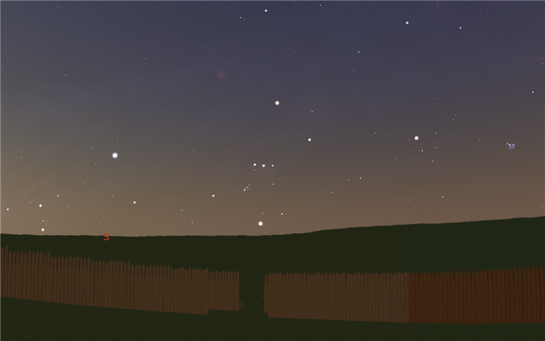
The right image shows a view towards the south-western entrance, with a chain of hills visible over the palisade where the entrance could only have been associated with a star (if we think about always astronomically oriented entrances; view created with Stellarium). Covering the horizon would have necessitated a palisade of over 7m height!
Of course the height of the palisades cannot be known with any certainty today (some of the models show posts of unequal length to symbolize this uncertainty), but the traces reamaining in the soil do not indicate deeper foundation of the palisades in the lower part, as would be expected for different length of the posts. So, while the palisades inhibited views from nearby, the idea of an "artificial horizon", over which only the sky can be seen, must be rejected.
In only a few sites, solar orientation can still be assumed. The strongest result was found for the site Pranhartsberg 2, where the north-western entrance follows the direction towards summer solstice sunset, maybe even further enhanced by two posts.
_possiblePosts_Magnetic.jpg)
The opposing entrance may have been associated with winter solstice sunrise, but appears disturbed in the magnetogram, the exact orientation therefore unsure. While these entrances does not follow the usual surface slope pattern, in a few other sites, solar and slope patterns almost coincide.
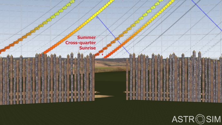
In Puch we could confirm the result of the preliminary study: the entrance orientation follows the cross-quarters, i.e., dates right in between solstices and equinoxes.
In the very same model, we can however also illustrate another hypothesis: The sight line through both entrances towards north-east points to the moonrise at the "minor standstill":
But this line also practically coincides with the terrain slope, just like in many other places like Schletz or Rosenburg. It seems arbitrary which astronomical explanation the reader prefers - these directions cannot be confirmed in any significant number of KGAs in our area, but with the result on the slopes also this KGA joins many others with a purely topographic pattern.
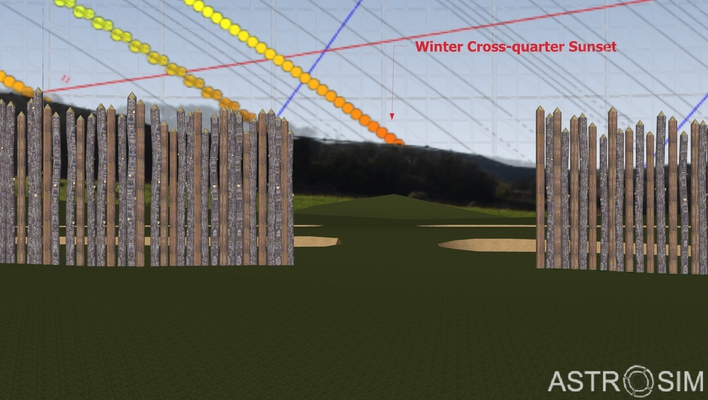
The south-western entrance in the KGA in Altruppersdorf was accentuated with strong posts according to traces seen in the magnetogram. On a flat map it appeared to point closely, but not exactly, towards winter solstice sunset. In the 3D model we see that the shadow cast by the (hypothesized) high posts would have missed the very center of the KGA (the usually assumed observing spot). A potential observer could have witnessed the event of a setting sun visible on the horizon framed by the posts only several steps east of the center. Again, this entrance therefore appears to have lost its astronomical value, simply leading - again - down the slope. On the other hand, the north-western entrance is oriented towards summer solstice sunset, but also again topographically: along the contour line.
Pranhartsberg 2 is a rare exception, showing a very clear solstice orientation not coinciding with terrain slope, and also the ground plan with its long entrance passages stands out from the crowd.
Technologically, we were able to develop new methods and software which can be applied towards similar questions in the future.